Dangerous weather conditions are affecting nearly the entire state of California over the coming days.
A second round of atmospheric rivers is bringing even more rain and flooding to Southern California in less than a week, exacerbating life-threatening flooding in the region for tens of millions of residents.

A man walks by a flooded road during a rain storm in Long Beach, Calif., on Feb. 1, 2024.
The system is forecast to be one of the most significant storms in state history, bringing the threat of flash flooding possible from Santa Barbara to Los Angeles, as well as heavy snow and wind in the mountains. Widespread power outages, roadway flooding, mudslides and the likelihood of numerous swift-water rescues are anticipated, according to the National Weather Service.
A flood watch has been issued for a large swath of the Golden State — from Redding to Sacramento, San Francisco, Los Angeles and San Diego — affecting 40 million people.
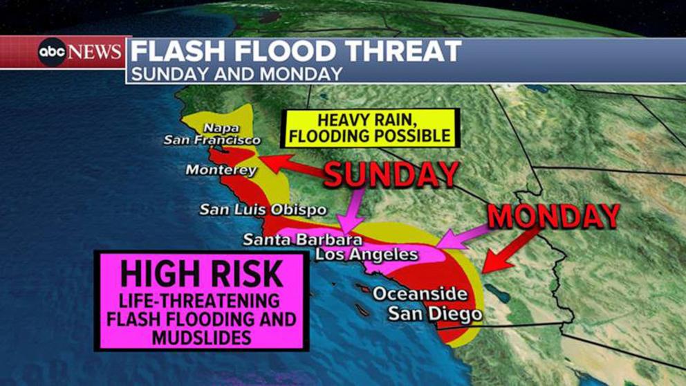
40 million Americans remain under a Flood Watch today in California, from Redding to Sacramento to San Francisco to Los Angeles and San Diego.
There is a high risk of excessive rainfall for much of Santa Barbara, Ventura and Los Angeles counties. This indicates a 70% risk of meeting life-threatening flash flood rainfall conditions, according to the NWS. Severe and widespread flash floods are expected in the area, even in places that don’t normally experience flash flooding.
MORE: California braces for life-threatening storm expected to bring flooding, mudslide threat
Some of the regions expected to receive the brunt of the moisture are already inundated from the last system.
Santa Barbara, where evacuation orders have been issued, has received 300% of its normal rainfall for this time of year in the last seven days alone. The ground in the region is extremely saturated and unable to soak in additional moisture, causing fast-falling rainwater to wash away immediately, creating conditions for significant flash flooding.
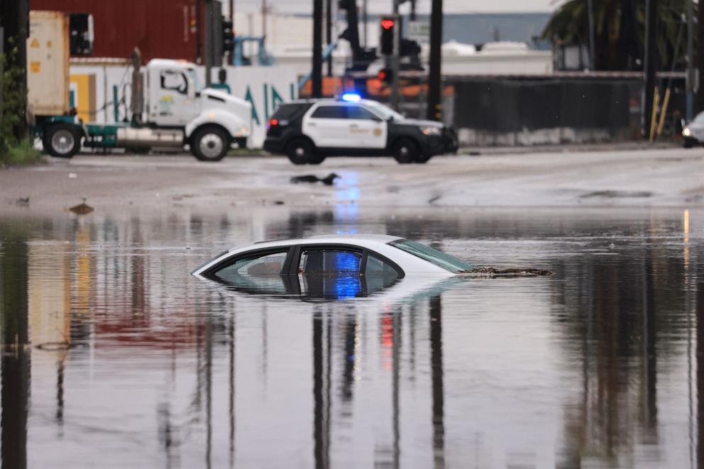
A car sits partially submerged on a flooded road during a rain storm in Long Beach, Calif., on Feb. 1, 2024.
Rain totals will be impressive in Santa Barbara, with 3 to 6 inches across the coastal and valley areas and 6 inches to a foot of rain for the foothills and mountains — especially from Santa Barbara County and south. Any thunderstorms that develop will bring the heaviest rain, up to 1.5 inches per hour, forecasts show.
The storm system is so strong that an extremely rare hurricane-force wind warning has been issued off the coast of Big Sur and Gorda, with wind gusts potentially reaching up to 90 mph.
MORE: Sea otters, once hunted to near extinction, are preventing coastal erosion as their populations grow, study finds
There is also a chance for brief tornadoes and waterspouts from San Luis Obispo to Los Angeles throughout Sunday. In the Los Angeles metro area, winds are expected to gust 25 to 40 mph on Sunday. Farther north, from Santa Barbara to San Luis Obispo, wind gusts from 50 to 70 mph are expected.
A high surf advisory has also been issued. Large breaking waves of 20 to 25 feet are expected in the Bay Area. Big Sur could see waves up to 35 feet, while Santa Barbara could experience waves up to 20 feet, forecasts show.
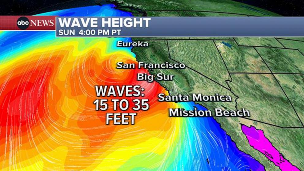
Large breaking waves of 20 to 25 feet for the Bay Area. Locally higher breaking waves of 25 to 35 feet near the Big Sur coast. Waves up to 20 feet off Santa Barbara.
A winter storm warning has been issued in the mountains outside Los Angeles. Heavy snow is expected to mix with winds up to 85 mph, which will cause impossible driving conditions, extensive tree damage and widespread power outages. Between 2 and 4 feet of snow is forecast in the highest elevations.
Along the Sierra Nevada mountain range, Lake Tahoe could see between 1 and 3 feet of snow, with other parts of the mountain range seeing 2 to 4 feet above 5,000 feet. At times, snowfall rates may exceed 3 inches per hour.
MORE: Historic California rain could foreshadow more extreme rainfall in coming weeks
Here’s to expect on the timing of the storm (all times Pacific):
Sunday, Feb. 4
Heavy rain began falling in the Bay Area around 2 a.m. Sunday, extending southward and reaching Santa Barbara by 7 a.m.
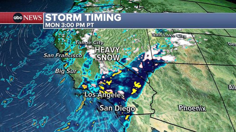
By 3 p.m., heavy rain will be situated over Santa Barbara to Los Angeles, with heavy snow in the mountains, as well as damaging winds.
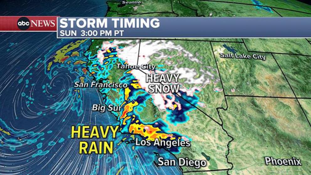
3pm PT (6pm ET) heavy rain will be situated over Santa Barbara to Los Angeles with heavy snow in the mountains, and don’t forget the damaging winds.
The heavy precipitation will slowly push south overnight but will continue in the Los Angeles area through the evening hours, making travel difficult and dangerous in places that flood.
MORE: What are atmospheric rivers? How climate change impacts the storms they produce
Monday, Feb. 5
By 4 a.m. Monday, the heaviest rain will be occurring in the San Diego area, triggering flood threats in the region.
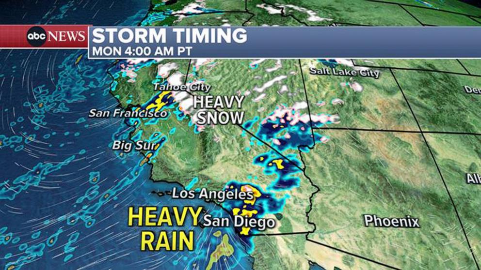
4am PT (7am ET) Monday – The heaviest rain is expected in the San Diego area where their flood threat comes into play.
Through the day, rain will still fall steadily from Santa Barbara to San Diego, which is why a flood watch is in effect there until Tuesday. The rain is not expected to let up, and water levels in streams and rivers will continue to rise, making some roadways impassable.
3pm Monday (6pm ET) – light to moderate rain continues from the Bay Area to San Diego along with heavy snow in the mountains. The flood threat will continue.
Light and moderate rain will continue from the Bay Area to San Diego — and heavy snow in the mountains — by 3 p.m., causing the flood threat to continue.
Tuesday, Feb. 6
Rain will still be coming down on Tuesday morning from Santa Barbara to San Diego, forecasts show.
In the afternoon on Tuesday, the rain will break up and become more scattered, but there will still be periodic heavy downpours from Santa Barbara to Los Angeles.
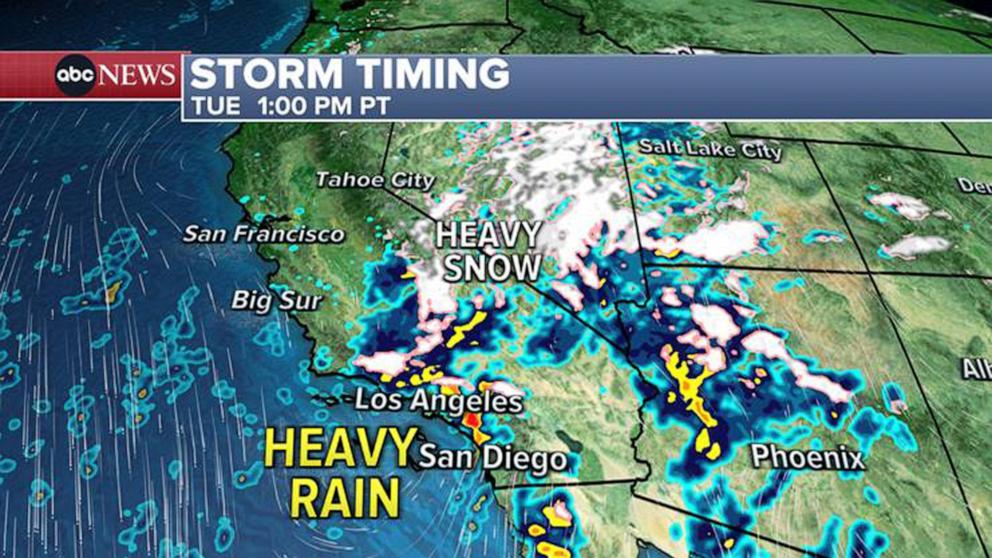
In the afternoon on Tuesday the rain will break up and become more scattered but there will still be periodic heavy downpours from Santa Barbara to Los Angeles.
Rain and snow are expected to be coming down across much of the West at this time.
News Related-
Russian court extends detention of Wall Street Journal reporter Gershkovich until end of January
-
Russian court extends detention of Wall Street Journal reporter Evan Gershkovich, arrested on espionage charges
-
Israel's economy recovered from previous wars with Hamas, but this one might go longer, hit harder
-
Stock market today: Asian shares mixed ahead of US consumer confidence and price data
-
EXCLUSIVE: ‘Sister Wives' star Christine Brown says her kids' happy marriages inspired her leave Kody Brown
-
NBA fans roast Clippers for losing to Nuggets without Jokic, Murray, Gordon
-
Panthers-Senators brawl ends in 10-minute penalty for all players on ice
-
CNBC Daily Open: Is record Black Friday sales spike a false dawn?
-
Freed Israeli hostage describes deteriorating conditions while being held by Hamas
-
High stakes and glitz mark the vote in Paris for the 2030 World Expo host
-
Biden’s unworkable nursing rule will harm seniors
-
Jalen Hurts: We did what we needed to do when it mattered the most
-
LeBron James takes NBA all-time minutes lead in career-worst loss
-
Vikings' Kevin O'Connell to evaluate Josh Dobbs, path forward at QB