Following a dry end to the post-holiday weekend, AccuWeather meteorologists say that the start of the new week will bring a similar theme. Residents across Oregon, Northern and Central California and Nevada into the interior West will continue to experience mostly sunny skies and dry conditions through Tuesday afternoon as high pressure dominates the region.
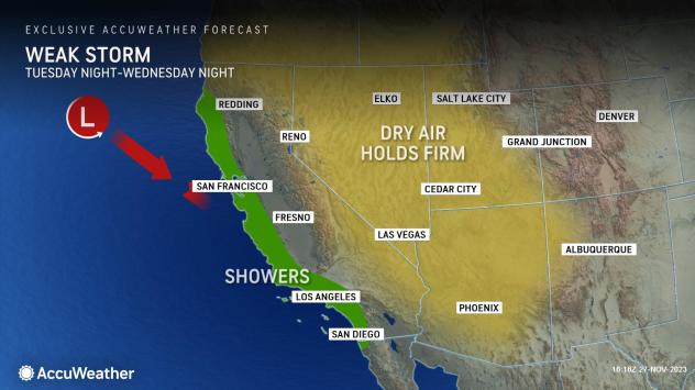
However, by Tuesday night, a new storm will begin to push into the California coast with rounds of showers. Locations such as San Francisco, Los Angeles and San Diego will share chances of showers as this feature tracks into the Southwest and brings slightly cooler conditions.
Temperatures are likely to fall between 5 and 10 degrees Fahrenheit from early in the week to late in the week along the California coast. Places like Santa Monica, California, are expected to range in the mid-60s F through Tuesday then dip to the upper 50s F from middle to late parts of the week. Similarly, San Diego residents are on track to have afternoon highs in the low 70s on Monday and Tuesday, but temperatures will reach only the lower to middle 60s by late in the week.
Many locations will tip the scales this week from starting out slightly above typical late-November conditions to temperatures falling just below the historical averages.
 Train of storms to drench western US into December |
The midweek storm will be far from a drenching atmospheric river, but it will be enough to have Californians reaching for their umbrellas.
Rain will taper off in most of California by Wednesday night as the system loses some steam as it tracks inland. As it continues its journey eastward over the Four Corners and eventually the South Central states, it will draw in moisture from the Gulf of Mexico that will deliver rain and thunderstorms to more than a dozen states.
Forecasters say that by later this week into the weekend, the activity will ramp up even more across portions of the West.
“After a short dry stretch across Washington and Oregon, a series of rain and snow is expected to move into the Northwest beginning Thursday and continuing through early next week,” AccuWeather Meteorologist Haley Taylor explained.
GET THE FREE ACCUWEATHER APP
•Have the app? Unlock AccuWeather Alerts™ with Premium+
The first of many storms will advance into the British Columbia coast, Washington and Oregon on Thursday, spreading periods of coastal rain and even wintry conditions to the Cascades and Olympic Mountains. Even metro areas like Seattle and Portland, Oregon, are expected to have damp conditions to finish the last day of November.
“Some of this rain could be heavy at times, and we could be looking at some flooding concerns for the region going into next week although the rain will be beneficial for the drought,” said Taylor.
Portions of the Northwest are currently facing moderate to severe drought levels, according to the U.S. Drought Monitor.
 |
In addition to the rain and mountain snow, gusty winds are expected to accompany the rounds of storms, especially for locations along the coast. Gusts directly along the shorelines could reach speeds of 45-55 mph as storms approach over the coming week. Mariners operating small craft should exercise caution and closely monitor area watches and warnings.
Beginning Thursday night, snowfall can begin to accumulate across the higher terrain in the Northwest. Through the weekend and even into early next week, chances will remain high for snow to spread into the northern and central Rocky Mountains.
“Snow levels can drop as low as 2,500 feet by Thursday night as the first storm moves through,” Taylor said. Snow levels are predicted to rise by Sunday, but snow could still potentially impact travel through major passes, like Snoqualmie Pass.
The heaviest snow totals could occur across the Cascade range, which can quickly disrupt travel across the higher terrain heading into the weekend. Even travelers on roads across the lower elevations near the coast could face travel delays due to rain and wind alone.
The influx of moisture will continue to target the West through the weekend into early next week. From Saturday to Sunday, a setup for significant rainfall can develop in western Washington and Oregon as yet another storm advances inland.
As ample rainfall persists into the first half of next week, it is not out of the question for some upslope regions on the western sides of the Cascades and coastal locations in Washington and Oregon to collect anywhere from 3-5 inches of rain from Thursday to Tuesday, with locally higher amounts possible.
AccuWeather meteorologists will continue to monitor the upcoming weather pattern across the West and provide the latest updates as the storms approach the region.
Want next-level safety, ad-free? Unlock advanced, hyperlocal severe weather alerts when you subscribe to Premium+ on the AccuWeather app. AccuWeather Alerts™ are prompted by our expert meteorologists who monitor and analyze dangerous weather risks 24/7 to keep you and your family safer.
News Related-
Russian court extends detention of Wall Street Journal reporter Gershkovich until end of January
-
Russian court extends detention of Wall Street Journal reporter Evan Gershkovich, arrested on espionage charges
-
Israel's economy recovered from previous wars with Hamas, but this one might go longer, hit harder
-
Stock market today: Asian shares mixed ahead of US consumer confidence and price data
-
EXCLUSIVE: ‘Sister Wives' star Christine Brown says her kids' happy marriages inspired her leave Kody Brown
-
NBA fans roast Clippers for losing to Nuggets without Jokic, Murray, Gordon
-
Panthers-Senators brawl ends in 10-minute penalty for all players on ice
-
CNBC Daily Open: Is record Black Friday sales spike a false dawn?
-
Freed Israeli hostage describes deteriorating conditions while being held by Hamas
-
High stakes and glitz mark the vote in Paris for the 2030 World Expo host
-
Biden’s unworkable nursing rule will harm seniors
-
Jalen Hurts: We did what we needed to do when it mattered the most
-
LeBron James takes NBA all-time minutes lead in career-worst loss
-
Vikings' Kevin O'Connell to evaluate Josh Dobbs, path forward at QB